Oronteus Finaeus is actually a normal map image builders. But the work is done Topografer Frenchman is still a profound mystery. Why ...?
In 1532, Oronteus Finaeus draw a map of the world. Not a problem if you are just a map drawn afterwards around Continental Europe, Africa, Asia, and most of America, but the remarkable thing is that Oronteus Finaeus describe sixth continent - the Antarctic (South Pole) ...! Though no one has ever sailed to the Antarctic ...!
And more alarmingly, the Antarctic coastline on a map produced by Finaeus - turned out exactly like a modern map of Antarctica today ...! Of course this is a remarkable, because the Antarctic continent was covered in a thick perennial ice up to 2 Kilometers ...
Where Finaeus knew all about it ...?? That is the mystery unsolved to this day.
I was finally attracted to slightly peel .....
Who Oronteus Finaeus?

Fine Oronce that's the name of his clan, was born in Briançon in 1494 and grew up in Paris. He was in prison in 1518. Although he himself was a mathematician, but in the year 1522 still received a medical degree from the University of Navarre in Paris.
In 1524, he again entered the prison and in the same year he made a sundial of ivory residue. In the 16th century, many people love the work of mathematicians. Finally Oronteus Fine expert appointed and employed in the defense fortification fortress Milan-Italy.
In 1531, he received an honorary degree at the Collège Royal Paris. At that moment his career climb wrote many scientific papers. The works that was published a.l:
Minutes of the science of astrology and astronomy tools. In 1520, he was the one who suggested that a lunar eclipse can be used to determine the longitude of a place.
Find map projections in 1519 and later produced the map of the world which we now use.
In the year 1544, calculate the value of pi (22:7) = (22 2/9) / 7, then improved to 47/15. He believed that the earth was the center of the universe.
Map it ...
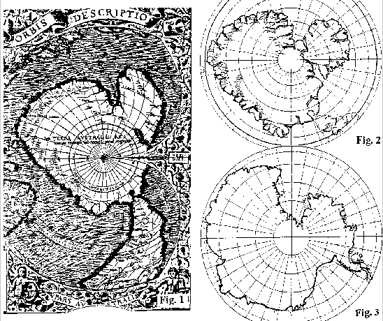
Figure 1 - Map Oronteus Finaeus tahun1532 in the southern hemisphere Figure 2 - Oronteus Finaeus draw back polar projection map of modern
Figure 3 - Map of modern Antarctica
This map is found in The Library Congress, Washington DC in 1960 by Charles Hapgood. Reads "drawn by Oronteus Finaeus in 1531". Almost exactly the mapping Piri Reis, Antarctica indicated by ice-free flowing like a river, drainage patterns and coastline.
Map Oronteus Finaeus more accurate than the other maps at that time. In fact, more accurate than any map made up to the year 1800.


0 comments:
Post a Comment